
File:Xhosa1851.jpg
Xhosa1851.jpg (512 × 312 pixels, file size: 60 KB, MIME type: image/jpeg)
| This is a file from the Wikimedia Commons. Information from its description page there is shown below. Commons is a freely licensed media file repository. You can help. |
Summary
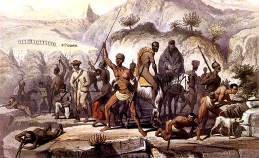
| Kafir and Hottentot war-party | |
|---|---|
| Artist |
H. R (Hugh Robinson) |
| Author |
Lumley Graham, and Hugh Robinson, Officers of the 43rd Lt.-Infantry |
| Title |
Kafir and Hottentot war-party |
| Object type | |
| Description |
English: A Kafir and Hottentot war-party scene, from Scenes in Kafirland, and Incidents in the Kafir War of 1851-2-3,
FIRST EDITION, [1854] The war started at Kaalhoek during Christmas time, 1850, and by 1852 the Water Kloof was secured by colonial forces. The ringleaders of the insurgents surrendered in 1853. Afrikaans: Insurgente van die 8ste Grensoorlog (ook: Bonte Oorlog), wat 'n posisie in die Water Kloof verdedig in die tweede jaar van die oorlog, 1851. Xhosa, Katrivier-khoikhoi en drosters word hier uitgebeeld. 'n Benaderde ligging word onder aangegee. Die oorlog het tydens Kersfees 1850 te Kaalhoek uitgebreek, en eers in 1852 is die insurgente uit die Water Kloof verdryf. Die insurgente se ringleiers het in 1853 oorgegee. |
| Date | 1854 |
| Source/Photographer | Anne S.K Brown Military Collection |
| Object location | | View this and other nearby images on: OpenStreetMap |
|---|
Licensing
|
This is a faithful photographic reproduction of a two-dimensional, public domain work of art. The work of art itself is in the public domain for the following reason:
The official position taken by the Wikimedia Foundation is that "faithful reproductions of two-dimensional public domain works of art are public domain".
This photographic reproduction is therefore also considered to be in the public domain in the United States. In other jurisdictions, re-use of this content may be restricted; see Reuse of PD-Art photographs for details. | ||||
Original upload log
Transferred from en.wikipedia to Commons by Naudefj using CommonsHelper.
- 2007-06-05 16:28 Dr. Blofeld 512×312× (61493 bytes) *http://home.earthlink.net/~cyberkiwi/soldiers/cape32.jpg Painting of the Xhosa wars
File history
Click on a date/time to view the file as it appeared at that time.
| Date/Time | Thumbnail | Dimensions | User | Comment | |
|---|---|---|---|---|---|
| current | 18:04, 1 January 2013 | | 512 × 312 (60 KB) | File Upload Bot (Magnus Manske) | Transfered from en.wikipedia by User:naudefj using CommonsHelper |
File usage
Global file usage
The following other wikis use this file:
- Usage on af.wikipedia.org
- Usage on ar.wikipedia.org
- Usage on ast.wikipedia.org
- Usage on de.wikipedia.org
- Usage on el.wikipedia.org
- Usage on es.wikipedia.org
- Usage on he.wikipedia.org
- Usage on it.wikipedia.org
- Usage on nl.wikipedia.org
- Usage on no.wikipedia.org
- Usage on uk.wikipedia.org
- Usage on www.wikidata.org
- Usage on xh.wikipedia.org